


SityTrail - Aiguilette des Houches - Bel Lachat

HG74250
User
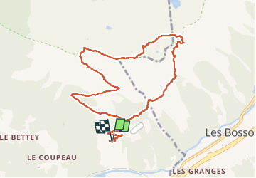

Length
11.7 km

Max alt
2303 m

Uphill gradient
1032 m
Km-Effort
25 km

Min alt
1329 m

Downhill gradient
1034 m
Boucle
Yes
Creation date :
2022-07-12 09:54:33.251
Updated on :
2022-07-12 11:54:29.584
5h46
Difficulty : Difficult

FREE GPS app for hiking
 SityTrail
IGN / Geographical institutes
SityTrail Plus
The world is yours!
About
Trail Walking of 11.7 km to be discovered at Auvergne-Rhône-Alpes, Upper Savoy, Les Houches. This trail is proposed by HG74250.
Description
Départ du Parc Merlet
Positioning
Country:
France
Region :
Auvergne-Rhône-Alpes
Department/Province :
Upper Savoy
Municipality :
Les Houches
Location:
Unknown
Start:(Dec)
Start:(UTM)
330313 ; 5085891 (32T) N.
Comments